Springfield to Chicago, 1973
In late June and early July of 1973, Mike Macewich and I rode our bikes through Illinois from Springfield to Chicago. I'm writing this account of our trip based on my memory, pictures we took on our trip, a paper I wrote in 1975 entitled Planning a Bicycle Camping Trip, recent conversations with Mike, and help from the Map Library at the University of Illinois, the LaSalle County Historical Society, and the Facebook group Tonica il. Yesterday and Today. This trip was 50 years ago, when Mike and I were both 19!
Our trip actually began in Chicago, where Mike and I lived. We took our bikes to Springfield either on an Amtrak train or a Greyhound bus. When we attended a bike rally in Springfield in 1971 we took our bikes on an Amtrak train from Chicago to Springfield and back. I'm going to guess that for the 1973 trip we used Amtrak to get to Springfield, because that's how we got there two years earlier, and taking the train did not require packing the bikes in boxes as it did on a bus.
After the pictures we took were developed I put notations on the backs of some of them and then put them all in a photo album, more or less in the order in which they were taken. I'm relying on those notations and that order as I write this post.
Itinerary
The paper I wrote in 1975 paper says that we rode 260 miles in nine days. Based on that information, the photos, and our memories, I believe we stayed at four campgrounds. Because of photos I'm certain we stayed at Riverside Park Campgrounds and Hickory Hill Campground, and Mike and I both remember staying with his grandmother in Joliet. Our best guess about the route we took is Springfield to Chicago 1973, and here's an outline of where we stayed, with the number following the name indicating the distance along the route:
- Riverside Park Camping Grounds 0
- Weldon Springs State Park? 49
- Hickory Hill Campground 101
- Illini State Park? 165
- Grandma's House 208
I remember that we left Riverside Park Campgrounds on Mike's birthday, June 27th. I think we took the train to Springfield on Saturday, June 23rd, spent four nights in Springfield, and then rode every day from June 27th through Sunday, July 1st.
Gear
I rode a 10-speed Mercier that had Simplex derailleurs and shifters and Mafac brakes. I might have bought it as early as 1969. It was stolen from my basement shortly after I moved to Manhattan in 1995.
Mike rode a 10-speed Peugeot UO-8 that he bought in 1972. He sold it a few years ago after not riding it for a long time.
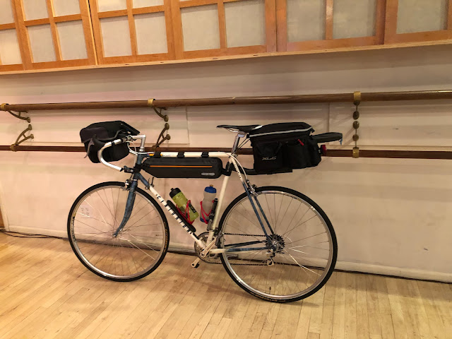
Mike and I each carried a Svea 123 stove and a Boy Scout cook kit. Between us we carried a single can of fuel (white gas, known as Coleman fuel) and a funnel for the stoves as well as a Primus 2220 lantern powered by canisters which I believe were filled with butane. Once it had been used, the mantle for the lantern would be destroyed by the vibration of riding so we carried a supply of mantles. Mike remembers that we slept in two tube tents but I recall only one. None of my pictures shows two tents. We each carried a blanket rather than a sleeping bag.
The picture below shows some of the gear we carried, all of which I still have but have not used since the 70s.

|
|
Lantern, mantles, stove, fuel can, funnel |
We carried our gear in handlebar bags, on rear racks, and in panniers mounted on the rear racks.
Springfield
While spending four nights at Riverside Park Camping Grounds, we visited both the Thomas Rees Memorial Carillon and Lincoln's home.
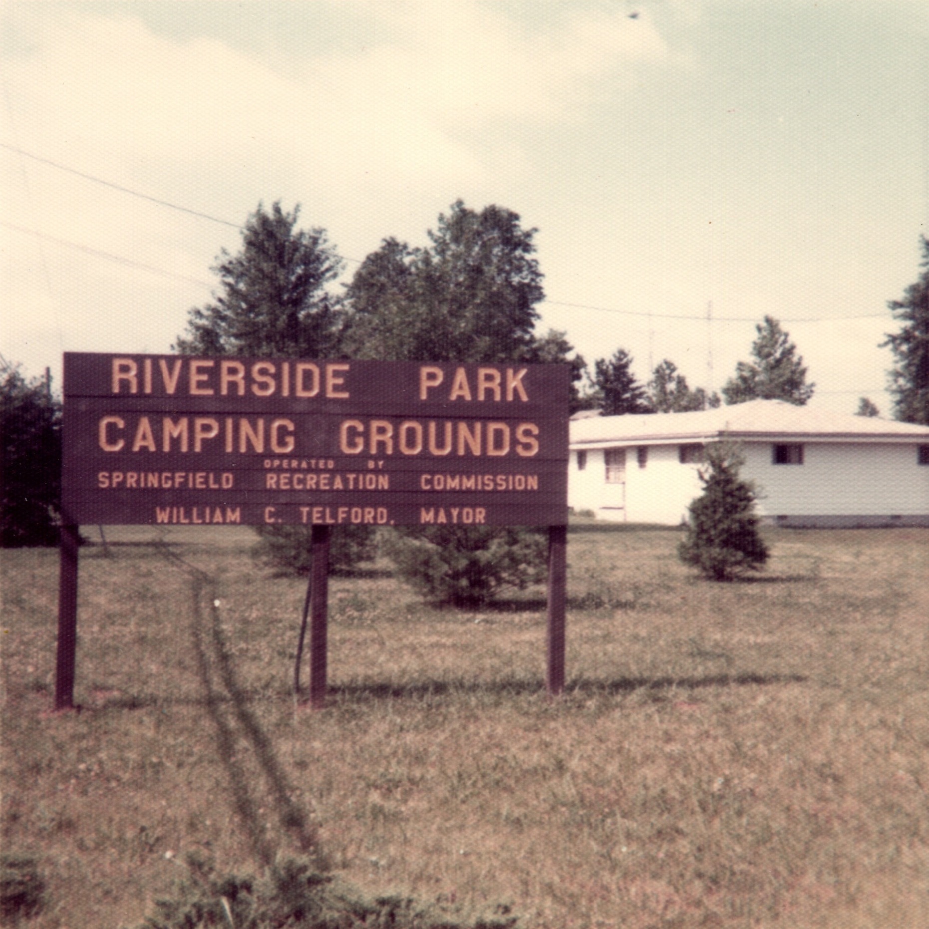
On one of the nights we were at Riverside there was a thunderstorm nearby. I remember rising off the ground in response to one of the crashes of thunder. I recall that our campsite was under some trees. We probably should have sought shelter indoors until the storm passed. I took several pictures of the menacing sky. Some of my friends made fun of these pictures. Are they that bad?


Before leaving Springfield we went to the home of Deb Churran who hosted us and others for the bike rally in 1971. After we rang the bell out came a man not wearing a shirt but with a pistol stuffed in the waist of his pants (Mike remembers he had the pistol in his hand). I think he told us Deb wasn't home and we got the hell out of there.
Riding Day 1: Riverside Park Camping Grounds to Weldon Springs State Park (?)
Here's Mike on his birthday, June 27th, the day we left Springfield.

Here he is riding out of the campground.

And here I am following him.

You don't see me in the first picture or Mike in the second because both pictures were staged, with each of us taking the picture of the other.
Almost immediately after leaving the campground, a small dog appeared on the road ahead of us (probably Johns Road) and threatened us with bodily harm if we proceeded. At least that's how Mike and I interpreted the dog's actions. I think we turned around and took Sandhill Road in order to avoid the dog.
In 2019, as part of my 4,500-mile 90-day solo trip, I spent a night at Riverside Park Camping Grounds. As I wrote in Riding Day 33 - July 12th, 2019, I didn't recognize anything about the campground. I suspect it had been substantially expanded.
About 16 miles into our ride we stopped before going under the Gillette Memorial Arch where Mike took the picture below. My recollection of having a rapid descent after going through the underpass is confirmed by the RideWithGPS route that shows an average grade of -5% for almost half a mile.

On my solo trip in 2019 I followed out of the campground the same route Mike and I had taken in 1973, at least as far as the overpass in the picture above. Here's what I wrote in Riding Day 34 - July 13th, 2019:
How is it that as I followed the route Mike and I had ridden none of it seemed familiar? Some of the route I rode might not have been what we rode in 1973, but most of it must have been the same. Even the underpass seemed familiar only because of the picture. I felt that I had no direct memory of it. When Mike and I were reconstructing our route, I told him I remembered a fast descent immediately after the underpass. Mike didn’t remember that, but my memory was confirmed as I sped down the hill.
I have no pictures associated with our second campground, which might have been Weldon Springs State Park. Mike remembers that we were not allowed in one of campgrounds but were allowed to camp just outside the campground. It might have been our second campground or it might have been our fourth.
Riding Day 2: Weldon Springs State Park (?) to Hickory Hill Campground
On our second riding day I recall riding through Bloomington-Normal when it was dark. My memory of it being dark is almost certainly incorrect because ten miles after leaving Bloomington-Normal we took the picture below (with "Mackinaw River" written on its back) as we crossed the Mackinaw River at mile 90.1 (which I determined using Google Street View and Satellite View).

Ten miles after crossing the Mackinaw River we arrived at Hickory Hill Campground, which had a swimming pool in which I'm sure we swam, although I don't remember doing so.

The picture below shows our campsite at Hickory Hill. Notice that there is only one tent visible. Could both of us have fit into that one tent? The large plastic sheet to the left was used to cover our bikes to protect them from the rain.

Riding Day 3: Hickory Hill Campground to Illini State Park (?)
In Wenona we met three boys and asked them how to get to Marseilles (Mar-SAY), where I think we planned to camp. One of the boys answered in a drawl, "You mean Mar-SALES?". We were carrying a map so I don't know why we asked the boys for directions.

After leaving Wenona we stopped at mile 141.0 to take several pictures at some railroad tracks that crossed Bailey Creek on a trestle bridge.


Using Google Street View and Satellite View I was unable to determine the location of the trestle bridge shown in the pictures above, so I wrote to the Map Library at the University of Illinois for help. Librarian Jenny Johnson suggested I use the USGS Historical Topographic Map Explorer to examine old maps. I was still unable to find the location of the trestle bridge, so Jenny suggested I write to the LaSalle County Historical Society. After I did so Amanda Carter posted my pictures and question at the Facebook group Tonica il. Yesterday and Today. Several people commented with the location of the bridge and said that it was long gone. I never would have found its location with Google Street View and Satellite View. Here’s what Google Street View shows looking toward where the bridge used to be:

Google Satellite shows Bailey’s Creek but no tracks or bridge.

Thank you Jenny Johnson, Amanda Carter, and all who responded in the Tonica il. Yesterday and Today Facebook group!
We crossed the Vermilion River at mile 144.4 (which I determined using Google Street View and Satellite View).


Notice in the pictures above how little gear we carried. I remember saying "30 pounds of bike and 30 pounds of gear". Notice also the lack of helmets, gloves, bike shoes, or lycra clothing, but both of us did use toe clips. The picture of me was planned to make me look like I'm riding, but actually I was leaning against the guard rail.
I think the picture below shows the gravel road we had to ride to get to our fourth campground, perhaps Illini State Park. Whichever campground it was, maybe it was the one in which Mike remembers we were not allowed but were allowed to camp just outside the campground.
Since we were not allowed into either our second or fourth campground, I think that we did not stay at both Weldon Springs State Park and Illini State Park, because I don't think we would have been denied entry into a state park. I think that either the second or fourth campground must have been a private campground.

In the picture below, notice again that there is only one tent visible, and the large plastic sheet covering our bikes to protect them from the rain. That's Mike inside the tent, with his hat on the ground at the opening. It's hard to imagine both of us in that tent, so I think Mike is right that we each took a tent.

Riding Day 4: Illini State Park (?) to Joliet
Mike and I both remember riding through an ugly industrial area, maybe containing a power plant, before we got to Joliet, and we related it to a book by Kurt Vonnegut. We have not been able to identify the location of the industrial area.
As we entered Joliet where we stayed with Mike's grandmother, we crossed the Des Plaines River on McDonough Street at mile 204.8 (which I determined using Google Street View and Satellite View).


Riding Day 5: Joliet to Chicago
On our way out of Joliet, at mile 211.3, we passed the Joliet prison, made famous by Steve Goodman in his song Lincoln Park Pirates. Mike reminded me that the Joliet prison was also featured at the beginning of the movie "The Blues Brothers" (see The Blues Brothers - The Pickup).
When I arrived home I was tan from being in the sun and strong from having ridden an average about 50 miles per day.
* * *
I find it both interesting and frustrating that Mike and I have forgotten or can't determine so many things I would now like to know:
- The second and fourth campgrounds in which we stayed
- How many tents we used
- Where we bought our food
- What we ate
- The location of the industrial area near Joliet
- Most of our route
Daniel Kahneman, on page 389 of Thinking Fast and Slow, posed the following question:
At the end of the vacation, all pictures and videos will be destroyed. Furthermore, you will swallow a potion that will wipe out all your memories of the vacation. How would this prospect affect your vacation plans? How much would you be willing to pay you it, relative to a normally memorable vacation?
In the video below, Kahneman discusses the difference between experience and memory, and at 11:13 talks about the question cited above.
I don't have an answer to Kahneman's question, but it's obvious to me that we forget most of our experiences, even if we document them with pictures and videos or ride records or blog posts.
Other Trips in the 70s
Besides the trip from Springfield to Chicago in 1973, there were three other bike camping trips I made in the 70s:
- 1972 - Chicago, IL, to Illinois Beach State Park in Zion, IL (and return), with Mike Macewich - 100 miles in 3 days
- 1974 - Marshfield, WI, to Chicago, IL, with Tom Sorgani - 360 miles in 11 days
- 1976 - Galena, IL, to Chicago, IL, with Mike Macewich and Ron Thielen - 70 miles in 2 days
Because I have no documentation for any of those trips, I will not be writing blog posts about them. But here are my recollections.
1972 - Chicago to Illinois Beach State Park
This trip was the first time I rode with my bike loaded with camping gear. As I started to ride I thought "I'm not sure I can do this". It rained for much of our ride to Zion. Because we arrived after dark when the park was closed, instead of pitching a tent we spent the night in a large, very clean bathroom building, each of us enjoying a bottle of Boone's Farm wine.
1974 - Marshfield to Chicago
Tom and I packed our bikes in bike boxes and rode with them on a bus from Chicago to Marshfield, where we spent one or more nights staying with my maternal grandmother and spending time with my cousin Bill Becker. Our route included the Elroy-Sparta State Trail, considered the first rail-to-trail in the world. That trail has three tunnels but we missed the northernmost one, the longest. We spent several days visiting Ken Nakamoto (a friend from high school) at Beloit college, even auditing an economics class. Somewhere in Wisconsin we were chased by three German Shepards, which we outran because we were riding downhill.
1976 - Galena to Chicago
For this trip we packed our bikes in bike boxes and rode with them on a bus from Chicago to Galena. We spent a night in the DeSoto House, an old hotel in Galena that opened in 1855 and where we had dinner in an elegant restaurant. The next day the trouble began shortly after we set off. On an early climb I thought we were in trouble when I saw both Mike and Ron walking while I continued to ride up the hill. Later Ron crashed (fortunately with no serious injury) when his handlebar turned one way and his front wheel the other way because he hadn't sufficiently tightened the bolt on his stem. Ron and Mike both broke spokes, at least one of them on the drive side of the rear wheel. All three of us had several pinch flats, probably because before the trip we had installed tires too narrow for our rims. As a result of all this trouble we arrived at White Pines Forest State Park after two days instead of one. We had allocated only three days for this trip but had another 100 miles to ride, which we knew we couldn't do in one day, and we couldn't extend the trip because of the start of the new school year. So the morning after we arrived at White Pines we went to the camp office and called our friend Earl Renquin to ask him to drive from Chicago to pick us up in his truck. We had awakened Earl who was still sleepy so he said he'd call back in half an hour or so. While we waited for his call, in walked Mike who worked with our friend Karen Isaacs (née Tyrell). When we told Mike our predicament he offered to drive us to Chicago in his van. We accepted his offer, with Ron getting out at DeKalb and then riding to Round Lake, while Mike Macewich and I continued in the van until Chicago.
I did not take another multi-day bike trip until forty years later when I took a three-day trip between Manhattan and West Point which you can read about in the section This Road I Ride of How I decided to ride 4000 miles next summer.
If you post a comment, please identify yourself.

Nice recounting of your travels. I wouldn't be concerned about forgetting details. Unless you have used multiple methods(photos, written, + review) to record information, they are not retained especially after 50 years.
ReplyDeleteI hope you are well,
Gary, Vienna, VA
I wonder what I would remember of the trip if we had not taken the pictures.
DeleteYou probably took Route 6 from Marseilles to Joliet. You would have encountered a chemical plant east of Morris and a power plant on the outskirts of Joliet. There are also oil refineries along the river south of Channahon.
ReplyDeleteI agree that we probably took Route 6. I found a chemical plant east of Morris and a power plan on the outskirts of Joliet, but with Google Street View nothing looks as industrial as what I remember.
DeleteI have followed your blogs extensively and so enjoy them. I have done over 20 supported weeklong bike trips (BonTon Roulet etc) but only 1 self supported bikecamping (Katy Trail). My mechanical abilities plus wrist strength for changing Gatorskins makes me leery of being independent, but I love reading about your *expeditions*.
ReplyDelete