Riding Day 69 - August 23rd, 2019
Start: Lehighton, PA
End: Newton, NJ
Miles: 82.5
Feet climbing per mile: 46
Record of today’s ride: https://ridewithgps.com/trips/38980928
Yesterday's post
Tomorrow's post
I had been planning to spend the night camping at Worthington State Forest, near the Delaware River. I suspect the camping would have been a wonderful experience, but the closest restaurants are 18 miles away. I didn’t want to count on being able to have my food delivered, so I changed my plan and made a reservation at the Econolodge in Newton, NJ, 70 miles from Lizard Creek Campground.
For the next night, my final night in this journey, I had planned to stay at Beaver Pond Campground, where I had camped previously, once to try out my tent, another time to test riding with all my gear. Unfortunately, when I tried to make a reservation I learned that all the sites were reserved. I would have enjoyed staying at Casa Hudson, in Haverstraw, but their rooms were all booked, as were the rooms at the West Point Motel where I spent two nights three years ago on my first multi-day trip in more than 40 years. When I spoke to Vicky, one of the owners, she remembered me and that I stayed in room 125. Wow! I’m happy to have found an Airbnb, a short walk to the West Point Motel and to Hacienda, the restaurant where I had dinner on my trip three years ago. The final of ride of this journey will follow the same route I rode home on my ride three years ago.
After making my reservations I had a quick swim in the pool, packed my gear, and departed at noon. The adventure started when I missed a turn on a trail that had been a railroad bed. By the time I realized my mistake I had ridden several miles, and getting back to my route added about 10 miles to the day’s ride. However it did also send me past some places where I could see the layers of earth exposed by the cutting required to make the rail bed.

The trail I was riding was made of crushed limestone on which I was getting more and more comfortable. Just as I had the thought “My road bike is also an off-road bike”, I hit a patch of mud and went down. I was only slightly bruised and my bike was undamaged, but the experience underscored the danger of thinking, instead of paying attention, when riding.

Before reconnecting with my original route I noticed a sign that said “Martin Guitar” and realized that I was in Nazareth. The factory was closed but I was pleased to see the building in which my 1971 D-35 had been made and later repaired.

I was using Google Maps biking directions to reconnect to my original route. For the most part it worked fine but one of the trails on which it put me became unrideable on my road bike, and I had to walk about a mile. I don’t understand why there isn’t an option Paved surfaces only. I’m going to see what I can do about that.

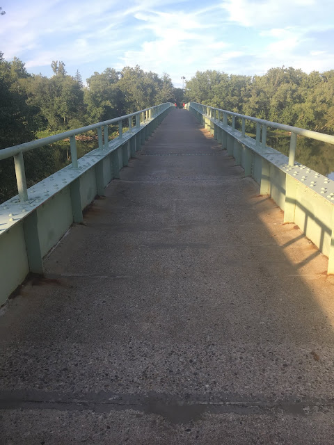
Shortly after returning to my original route I found myself about to cross the Delaware River on the Columbia Portland Bridge. One of the toll agents ran out and waved me down, telling me I can’t cross that bridge but should use the pedestrian bridge a short distance farther north.
Shortly after crossing the Delaware River my route, built with Google Maps biking directions, put me on another trail not appropriate for my road bike. I then created a new route using Google Maps driving directions. This worked well, since the wide shoulder kept me out of the heavy traffic.
Eventually the shoulder became inconsistent, and the sun was setting. I used Google Maps biking directions to create a route to my destination that used back roads. I rode the final hour in darkness. I’m glad the traffic was very light and the surfaces of the roads excellent because my bright headlight is not as bright as I’d like it to be in such a situation.
After a quick shower, shave, and change of clothes, at 9:15 I arrived at Bella Italia next to the Econolodge where I'm spending the night, just before the kitchen was to close.
Yesterday's post
Tomorrow's post
End: Newton, NJ
Miles: 82.5
Feet climbing per mile: 46
Record of today’s ride: https://ridewithgps.com/trips/38980928
Yesterday's post
Tomorrow's post
I had been planning to spend the night camping at Worthington State Forest, near the Delaware River. I suspect the camping would have been a wonderful experience, but the closest restaurants are 18 miles away. I didn’t want to count on being able to have my food delivered, so I changed my plan and made a reservation at the Econolodge in Newton, NJ, 70 miles from Lizard Creek Campground.
For the next night, my final night in this journey, I had planned to stay at Beaver Pond Campground, where I had camped previously, once to try out my tent, another time to test riding with all my gear. Unfortunately, when I tried to make a reservation I learned that all the sites were reserved. I would have enjoyed staying at Casa Hudson, in Haverstraw, but their rooms were all booked, as were the rooms at the West Point Motel where I spent two nights three years ago on my first multi-day trip in more than 40 years. When I spoke to Vicky, one of the owners, she remembered me and that I stayed in room 125. Wow! I’m happy to have found an Airbnb, a short walk to the West Point Motel and to Hacienda, the restaurant where I had dinner on my trip three years ago. The final of ride of this journey will follow the same route I rode home on my ride three years ago.
After making my reservations I had a quick swim in the pool, packed my gear, and departed at noon. The adventure started when I missed a turn on a trail that had been a railroad bed. By the time I realized my mistake I had ridden several miles, and getting back to my route added about 10 miles to the day’s ride. However it did also send me past some places where I could see the layers of earth exposed by the cutting required to make the rail bed.

The trail I was riding was made of crushed limestone on which I was getting more and more comfortable. Just as I had the thought “My road bike is also an off-road bike”, I hit a patch of mud and went down. I was only slightly bruised and my bike was undamaged, but the experience underscored the danger of thinking, instead of paying attention, when riding.

Before reconnecting with my original route I noticed a sign that said “Martin Guitar” and realized that I was in Nazareth. The factory was closed but I was pleased to see the building in which my 1971 D-35 had been made and later repaired.

I was using Google Maps biking directions to reconnect to my original route. For the most part it worked fine but one of the trails on which it put me became unrideable on my road bike, and I had to walk about a mile. I don’t understand why there isn’t an option Paved surfaces only. I’m going to see what I can do about that.

Shortly after returning to my original route I found myself about to cross the Delaware River on the Columbia Portland Bridge. One of the toll agents ran out and waved me down, telling me I can’t cross that bridge but should use the pedestrian bridge a short distance farther north.

Shortly after crossing the Delaware River my route, built with Google Maps biking directions, put me on another trail not appropriate for my road bike. I then created a new route using Google Maps driving directions. This worked well, since the wide shoulder kept me out of the heavy traffic.
 |
| Not for a road bike |
Eventually the shoulder became inconsistent, and the sun was setting. I used Google Maps biking directions to create a route to my destination that used back roads. I rode the final hour in darkness. I’m glad the traffic was very light and the surfaces of the roads excellent because my bright headlight is not as bright as I’d like it to be in such a situation.
After a quick shower, shave, and change of clothes, at 9:15 I arrived at Bella Italia next to the Econolodge where I'm spending the night, just before the kitchen was to close.
Yesterday's post
Tomorrow's post

Comments
Post a Comment